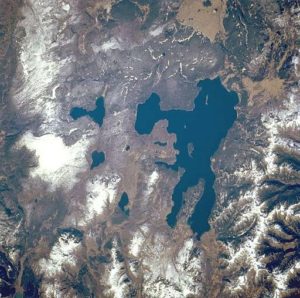
Image by NASA [Public domain], via Wikimedia Commons:
Yellowstone National Park, the largest national park in the United States, and Yellowstone Lake, the largest high-mountain lake in North America [139 square miles (360 square kilometers)], are featured in this west-southwest-looking, low-oblique photograph. The park lies atop a massive, dish-shaped, volcanic caldera approximately 30 miles (48 kilometers) by 45 miles (72 kilometers) in size . . . . sits on one of the hottest hot spots on earth.
Example Challenge: Volcanos, Icebergs, and . . . Cats?
As an example of a challenge, we chose the “Earth” category, and the challenge entitled “Hazards and Disasters.” Looking at the link for the challenge, it says “volcanos-icebergs-cats-space.”
Most likely, the third item refers to CATS, NASA’s Cloud Aerosol Transport System, launched in 2014, which provides information on cloud and aerosol layers, as well as information on particle size and shape of cloud formations.
The challenge is described thusly:
Background
The world is a big place. And there’s a lot to see. Too much to see, in fact. NASA’s fleet of Earth-observing satellites looks at the entire planet every day, silently observing volcanoes erupt, icebergs calve, and cat-shaped clouds form. Some of these events are found by scientists looking for them, but many more go unnoticed due to the sheer volume of satellite imagery available. Everyone finds different aspects of our planet interesting; and this challenge encourages you to find and share from your own perspectives.
Challenge
We need you to develop an app to crowdsource the discovery of “interesting” natural events as observed from space using data from NASA’s Earth observation satellites — such as wildfires burning, volcanoes erupting, or icebergs cracking. If all of you are helping us look for Earth events, by using a common interface you create with this challenge, we can discover more together than a few scientists can discover alone. And, we can share your discoveries with the world.
Considerations
The solution can be a prototype app that encourages users to interactively browse any set of NASA’s satellite imagery to find and tag “interesting” events.
“Interesting” is in the eye of the app designer such as a “Hot or Not” app for volcanoes or an interface to find the most cat-shaped clouds being formed.
The solution can also use a scoring system to encourage competition amongst users.
Examples include an interface to “vote up” or “vote down” user-submitted events or providing bonus points to users who are the first to find a new event.Sample Resources(Participants do not have to use these resources, and NASA in no way endorses any particular entity listed).
Natural events visible from NASA satellites: http://earthobservatory.nasa.gov/NaturalHazards/
Interactive interface to browse satellite imagery products: https://earthdata.nasa.gov/worldview
Sample mapping code to use NASA’s satellite imagery API: https://github.com/nasa-gibs/gibs-web-examples
NASA’s satellite imagery API: https://wiki.earthdata.nasa.gov/display/GIBS/
Background on hazards and disasters visible from NASA satellites: https://earthdata.nasa.gov/data/near-real-time-data/data/hazards-and-disasters
Some challenges provide videos which are time-consuming to view. The “Hazards and Disasters” challenge provides links to explore. Given the complex possibilities of this single example challenge, you can see that it may be most efficient to hone in on a challenge fairly quickly, so that your time may be spent mainly on honing your project idea, utilizing your strengths and skill set.
You will find the above challenge here.
See the next page for information about how a winning project was envisioned, had a team formed, and was developed in the accelerated environment of the 2014 SpaceAppsChallenge.


