How do you know where to walk if you inhabit a fenland in Britain?
In trying to visualize life in the fenlands, one needs to recall that fenlands may have unsafe areas for travel. Much effort was expended to create a safe passage across a fenland.
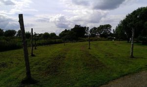
The photographer contributing the image above, Midnightblueowl, states:
These wooden posts mark the positions of the original Bronze Age trackway at Flag Fen in Cambridgeshire, Eastern England.
The Wikipedia article about the Flag Fen trackway elaborates that such a trackway would have been covered with timbers.
A Neolithic trackway once ran across what archaeologists have termed as the “Flag Fen Basin”, from a dryland area known as Fengate,[4] to a natural clay island called Northey[1] (now the site of Whittlesey).[5] The basin is an embayment of low-lying land on the western margins of the Fens.[1] The level of inundation by 1300 BC led to the occupants’ constructing a timber causeway along the trackway route.[5]
The causeway, and center platform, were formed by driving ‘thousands of posts with long pencil-like tips’ through the ‘accumulating peaty muds’ and into the firmer ground below.[5] The resulting structure covered three and a half acres.
Below is an image of a more modest trackway using modern lumber, rather than the rough-hewn, larger timbers that likely covered the bronze age trackway at Flag Fen. The image below is of a “restored” trackway at Dowrog Common.
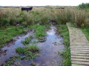
The Dowrog Common photo is described as:
Dowrog Common SSSI This expanse of swampy common land has been used for grazing and turfcutting for many centuries. Since becoming an SSSI in 1954 it has been managed to preserve its biodiverse richness in animal, insect and plant life.
The area was once known as Tyr-y-Pererinion, or the Pilgrim’s Land and the ancient Ffos y Mynach/Monks’ Ditch track still crosses it. The name’Dowrog’ is said to derive from ‘Cug glas y ddyfrog’ or the watery green hillock.
Timber spars laid across the bog to make a trackway were found here in the mid C18, a practice used from prehistoric times to enable access across wetland areas. The slatted causeways seen here are the modern version but they are now broken, sunk or overgrown in several places so that following the monks’ route in wet weather is quite a tricky business.
In contrast to the trackway, above, the image below is of an alternative form of roadbuilding, a “droveway.” Here, the reconstructed droveway appears cut through the peat to the underlying, more solid ground. According to the source article, a prehistoric droveway was used for moving livestock from one location to another.
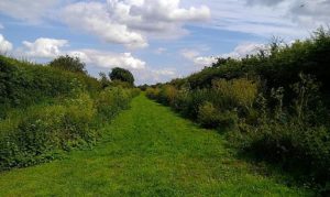
This image is described by photographer, Midnightblueowl:
The reconstructed Bronze Age droveway at Flag Fen in Cambridgeshire, Eastern England.
See the original image at Wikimedia Commons.
Following such marked-out paths, a traveler across peaty or wetland countryside could rely on a safe passage, avoiding pockets of quicksand-type peat which could swallow up an unsuspecting traveler who treads on ground that looks solid, but is neither safe nor solid.
See the original image of the Flag Fen wooden posts at Wikimedia.
Also see the Dowrog Common image by ceridwen at Wikimedia.