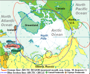
 Azimuthal Map of Arctic Region adapted from map by Atom at cs.wikipedia [Public domain], from Wikimedia Commons
By February, 2015, satellite images revealed even more Siberian craters.
The Yamal and Taymyr Peninsula locations, of the first three Siberian craters found, are circled on the map above. New craters were then found on the Yamal Peninsula.
Until now, only three large craters were known about in northern Russia with several scientific sources speculating last year that heating from above the surface due to unusually warm climatic conditions, and from below, due to geological fault lines, led to a huge release of gas hydrates, so causing the formation of these craters in Arctic regions.
Two of the newly-discovered large craters – also known as funnels to scientists – have turned into lakes, revealed Professor Bogoyavlensky, deputy director of the Moscow-based Oil and Gas Research Institute, part of the Russian Academy of Sciences.
Examination using satellite images has helped Russian experts understand that the craters are more widespread than was first realised, with one large hole surrounded by as many as 20 mini-craters, The Siberian Times can reveal.
According to The Siberian Times, who provides pictures of the four arctic craters now named B1, B2, B3, and B4, seven craters were known in February, 2015, but exact locations were known for only those four craters.
The February 23, 2015 article in The Siberian Times is well worth a visit, as it provides satellite pictures of the craters and their locations.
To see a video of field examination of the Siberian Craters, and why it initially delayed, visit the next page.